Home
FAQ
Patents
memoir
GPS-Phase1nds
NRL
National Medal of Technology
Documentation
Contact
Associates
Links
Gallery
GPS INVENTOR
|
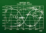
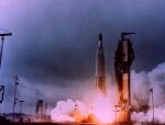
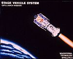
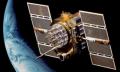
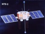
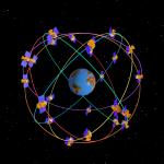
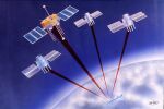
Roger L. Easton is the principal inventor and designer of the Global Positioning System (GPS). Considering the 1992 Collier Trophy that was awarded to the GPS team on 4 May 1993 supports this claim. The Vice Chief of Naval Operations, ADM Stan Arthur, accepted the award on behalf of the Navy and the United States Naval Research Laboratory (NRL). During his remarks, he made it absolutely clear to the audience that NRL led the way to GPS and took special note that NRL's Roger Easton actually "fathered" the idea. Two of Roger Easton's patents laid the foundation for the fundamental operation of GPS. All critical decisions related to the GPS system architecture resulted from the NRL TIMATION concept. NRL scientists also, designed, built, and orbited four satellites that were used to prove the feasibility of the proposed satellite navigation concept. Two satellites, TIMATION I & II, were flown in 1967 and 1969 to demonstrate the concept of using synchronized clocks that provided passive ranging signals that were used for navigation and time synchronization. The Navigation Technology Satellite I (NTS-1), flown in 1974, introduced rubidium atomic clocks; and, NTS-2, flown in 1977, introduced cesium atomic clocks. Roger Easton led the team of NRL scientists that provided the foundation for the revolutionary new Department of Defense (DoD) navigation and time transfer system. that is now known as GPS. The citation accompanying the presentation of the Collier Trophy honored the GPS team for "the most significant development for safe and efficient navigation and surveillance of air and spacecraft since the introduction of radio navigation fifty years ago." Of the five organizations that were recognized, two were not involved at the time that GPS was formally declared a DoD system. The remaining three organizations were: (1) the U.S. Air Force, (2) the Aerospace Corporation, and (3) the U.S. Naval Research Laboratory. The Air Force 621-B proposal resulted primarily from work done by the Aerospace Corporation; hence, there were really only two finalists in the intense competition for the DoD Defense Navigation Satellite System. The conclusion, using this line of reasoning, would be reached by comparing the current GPS system configuration with the 621-B and NRL TIMATION proposals. The GPS fundamental concept of using stable clocks in the satellites for controlling precise time and navigation signals, and the mid-altitude constellation were a result of the NRL-proposed design for GPS. Roger Easton joined NRL as a Physicist in 1943 and helped NRL's efforts to bring World War II to a close. The possibility of using orbiting spacecraft for both scientific and military purposes was recognized and actively pursed by a number of NRL scientists. By 1955, Roger Easton was making significant contributions to NRL's plan for a program to employ artificial satellites that would first be used in the field of geodesy. The document titled "A Scientific Satellite Program", dated April 13, 1955, describes the NRL plan. Easton continued his work at NRL by helping to develop the MINITRACK system, which would track a satellite that broadcast a signal on a known frequency. Roger Easton is credited with designing the Vanguard I satellite that was actively tracked by the MINITRACK system. The Vanguard I satellite was launched into orbit on 17 March 1958 and remains today the oldest manmade object in earth orbit. The three NRL Vanguard satellites significantly contributed to the science of geodesy by providing data that was used to determine that the earth is more pear shaped. At the time that the Soviet Union launched the world's first manmade satellite into orbit on 4 October 1957, the United States had no means to detect and track the orbits of unannounced satellites. The first solution to this problem was provided by Roger Easton who conceived the idea of extending the MINITRACK concept to track unknown satellites in orbit around the earth. This proposal was presented to the Advanced Research Project Agency (ARPA) who approved the novel idea. Easton was made the head of the NRL Space Applications Branch in 1958 and given the charter to quickly implement his plan. Construction of the U.S. Navy Space Surveillance System began in 1958 under the sponsorship of ARPA. Initial operational capability was achieved in 1960, and the system was declared operational in 1966. This system was the first to detect, track, and determine the orbits all types of earth-orbiting satellites, space vehicles, and other orbiting objects. The fact that Easton is the inventor and principal designer of the Navy Space Surveillance System has already been recognized by NRL. In 1960, he was given the Navy Distinguished Civilian Service Award. The citation reads "For his exceptional leadership and scientific ingenuity which have led to the successful development of the Navy's Space Surveillance System. Roger Easton early-recognized the need to detect non-radiating earth satellites and initially proposed such a system". This system has subsequently been incorporated in the Naval Space Command and supports the U.S. Space Command as an integral part of the national Space Detection and Tracking System (SPADATS). A recent NRL Labstracts article, dated 30 January 1995, notes that "The Naval Space Surveillance System continues to be a vital part of the U.S. space surveillance capabilities and is actively being modernized while maintaining full operational capability by the NRL space Applications Branch in cooperation with NAVSPACECOM." The present day system detects and keeps track of nearly 5,000 objects daily and has catalogued nearly 15,000 objects during its 35 years of operation. The origin of Roger Easton's plan that led to the use of satellites for navigation and precise time transfer can be traced to the document titled "A Scientific Satellite Program, dated 13 April 1955, that on page 10 states "By observing the satellite it would also be possible to determine the absolute longitudes and latitudes by observation of the satellite. Such observations would also yield the height of the observer above the center of the earth". Roger Easton conceived the idea of using synchronized clocks in the satellites while conducting a ranging and velocity experiment that would enhance the capability of the Navy Space Surveillance System. One of Roger Easton's key patents, filed in 1963, that provided the basis for GPS passive ranging and the simultaneous synchronization of the navigator's clock with the satellite clock. The formation of GPS can be traced to the memorandum issued by Deputy Secretary of Defense William P. Clements, Jr. dated April 17, 1973, on the subject "Defense Navigation Satellite Development Program (DNSDP)". This memorandum envisioned the Air Force launching satellites into the 621B geosynchronous constellation. After a Naval Weapons Laboratory report, which showed that some of the 621B satellites would be orbitally unstable, and other deficiencies of the concept became apparent, the program changed direction at the "Labor Day Conference" in 1973. At this conference, the NRL TIMATION technology and constellation design was adopted. In 1973, after the formation of the GPS Joint Program Office, NRL's efforts were directed towards demonstrating and proving key GPS concepts. The NRL-designed and built Navigation Technology Satellites, NTS-1 and NTS-2, provided the space qualification test for rubidium and cesium atomic clocks, the first broadcast of the GPS spread spectrum signal from space, verification of the relativistic clock effect for GPS, measurement of radiation effects, laser retro reflector tracking, longevity effects on solar cells, and initial orbital calculations. The two NTS spacecraft also demonstrated the worldwide transfer of time and validated the GPS error budget. The instantaneous three-dimensional position determination capability provided by GPS is possible because of Roger Easton's concept of using synchronized atomic clocks in the Navstar GPS satellites, combined with simultaneous passive ranging measurements to four or more satellites. Because of the inherent syntonization provided by the atomic clocks, four or more simultaneous Doppler measurements provide a near-instantaneous measurement of velocity in all three components. In addition to the position, velocity, and passive time transfer capability of GPS, it is also possible to completely determine the navigator's attitude through the use of an antenna array-that is the direct application of the Space Surveillance System interferometer type of measurement. The NRL Navigation Technology Satellite NTS-2, designed and built under the sponsorship of the GPS Joint Program Office, was the first to broadcast the GPS spread spectrum signal and used an NRL-built relativistic synthesizer to offset the transmitted signal so that GPS time would run at the same rate as Coordinated Universal Time (UTC). Roger L. Easton is the principal inventor and designer of two operationally successful DoD systems. GPS is now widely recognized as the most significant development in the field of navigation since the introduction of radio navigation 50 years ago. It is now time that the United States and the world recognize the inventor of GPS. |